Showing 1349 items matching railway map
-
 Glenelg Shire Council Cultural Collection
Map, Railway Map of Victoria, n.d
... Railway Map of Victoria...Railway map, paper on fabric backing, wooden support top... Cliff Street Portland great-ocean-road Map Map Railway Map ...Port of Portland CollectionFront: verso - 'Way and Works branch railway Department Melbourne Dec 1954.'port of portland archives, railway, map, 1954, 1950s -
 Ballarat Tramway Museum
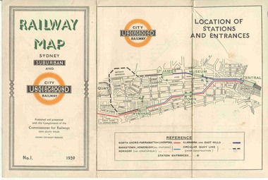
Map, NSWGR, "Railway Map of Sydney Suburban and Underground" - 1939, 1939
... "Railway Map of Sydney Suburban and Underground" - 1939... Railway Map... as No.1. Title "Railway Map of Sydney Suburban and Underground... and where the trains ran. Issued as No.1. Title "Railway Map ...Light card or Heavy paper. Colour map showing location of Sydney stations and entrances and where the trains ran. Issued as No.1. Title "Railway Map of Sydney Suburban and Underground" - 1939. Handle with care - both copies.trams, tramways, sydney, railway map, suburban and underground, trams -
 Federation University Historical Collection
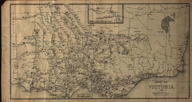
Map, Railway Map of Victoria, 1930
... Railway Map of Victoria...Cardboard map of Victorian railway system in 1930. Maps out... Railway Map of Victoria Cardboard map of Victorian railway system ...Cardboard map of Victorian railway system in 1930. Maps out all train-lines in Victoria and into New South Wales. map, railway, train-lines, victoria, victorian railways, railway lines -
 Parks Victoria - Mount Buffalo Chalet
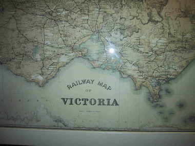
Map, "Railway Map of Victoria"
... "Railway Map of Victoria"...Large railway map of Victoria, Melbourne & Ballarat framed... Mount Buffalo National Park Mt Buffalo high-country Map "Railway ...Large framed map of Victoria, showing Victorias extensive rail network. Printed by Victorian Railways and is one of a number of 'framed pictures, particularly photographs of scenery, which have always been a feature of the Chalet.' (Pg 83. Historica, 2011) This map has been a permanent fixture situated in the hallway alongside the ballroom leading to the ski hire area since the 1950's and most likely earlier. Listed in Draft Inventory of Significant Collection ItemsLarge railway map of Victoria, Melbourne & Ballarat framed in white painted wood. Scale eight miles to one inch. Areas of the map have been whited out.Yes -
 Orbost & District Historical Society
map, Railway Map of Victoria, 1.8.1965
... Railway Map of Victoria...map-railway Victorian-Railways...A large rectangular shaped paper map of all railway... gippsland map Railway Map of Victoria A large rectangular shaped ...The Bairnsdale-Orbost railway was opened in 1916 to serve the agricultural and timber industry. Because of the decline in traffic and heavy operating costs, the line was finally closed in August, 1987.This item is associated with the history of the Orbost-Bairnsdale railway line and therefore reflects the role that the rail line played in the social and economic history of Orbost.A large rectangular shaped paper map of all railway stations in Victoria. It is dated 1st August 1965. It is divided into grids. Stations are listed around the map. A key is provided and each station has a grid reference.map-railway victorian-railways -
Whitehorse Historical Society Inc.
Map, Railway map of Victoria, 1912
... Railway map of Victoria...Detailed map of railways in Victoria including adjacent...Map Map Railway map of Victoria Detailed map of railways ...Detailed map of railways in Victoria including adjacent areas of New South Wales.Detailed map of railways in Victoria including adjacent areas of New South Wales. Also shows 'principal coach routes'. On verso map of suburban lines with eastern line as far as Croydon and Bayswater. key numbers on map linked to pages of a timetable.Detailed map of railways in Victoria including adjacent areas of New South Wales.maps, railways -
Ringwood and District Historical Society
Envelope, Packet: War Workers (WW2) - Fall of Singapore, Burma Railway Map, Special Editions of Newspapers 1992-993
... Railway Map, Special Editions of Newspapers 1992-993... Destiny Struck", Australia at War, Map of Burma Railway...) - Fall of Singapore, Burma Railway Map, Special Editions ...World War II - Newspapers - 50th anniversary editions; The Australian - Special edition "The Fall of Singapore", "The Day Destiny Struck", Australia at War, Map of Burma Railway -
 Montmorency/Eltham RSL Sub Branch
Map - Burma Railway Map (annotated)
... Burma Railway Map (annotated)... View Road Montmorency melbourne Burma Railway Map (annotated ...Fold-out sheet of paper showing and describing the details of locations along the railway; part of a numbered series of maps -
 Kiewa Valley Historical Society
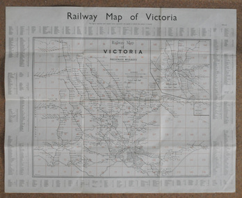
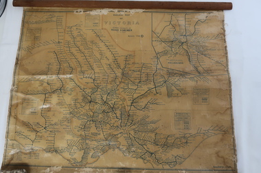
Map - Railway Map of Victoria, Amended to 1/11/1945
... Map - Railway Map of Victoria... - Railway Map of Victoria Amended to 1/11/1945 Plastic on parchment ...Railways began in the 1850s and were privately owned and operated. Later they were taken over by the Victorian Government reaching a peak in the early 1940s.Steam trains were followed by electric trains with both running after the war in 1945.Bright was the closest station to the Kiewa Valley but road transport was used more often as the Kiewa Valley Highway was improved with the construction of the Kiewa Hydro Electric Scheme. To travel to Melbourne or Sydney by train residents went via Wodonga/Albury where they also did their shopping.Plastic on parchment with detailed railway routes (in green) across Victoria including each district's 'Road Foremen' and 'Depots'. There is a length of flat wood attached by 10 tacks across the top of the mapvictorian railways 1945, trains, transport -
 Kew Historical Society Inc
Map, Osboldstone & Co Pty Ltd, Railway and Tramway Map of Melbourne and Suburbs With Tram Timetables, 1917
... Railway and Tramway Map of Melbourne and Suburbs With Tram...The Railway and Tramway Map of Melbourne and Suburbs... Map Railway and Tramway Map of Melbourne and Suburbs With Tram ...The Railway and Tramway Map of Melbourne and Suburbs With Tram Timetables lists existing Cable Tram Services before the entire network was electrified. By 1917 the tramways system was divided into regions including: the Melbourne Cable Tram Service; Prahran - Malvern Electric Trams; Hawthorn Electric Trams; Melbourne, Brunswick and Coburg Electric Trams; and Brighton Beach Electric Trams. The old Outer Circle railway line is marked as ending in Deepdene, with the remainder of the line to Fairfield marked as 'Unused'. The Kew tram along High Street in 1917 ended at the Harp Junction. The Kew Spur Line is also marked on the map.The Railway and Tramway Map of Melbourne and Suburbs With Tram Timetables is historically significant as it captures at a point in time, 1917, the development of public transport infrastructure in Melbourne. As such it illustrrates the theme: Connecting Victorians by transport and communications.Printed card-covered pocket sized map that folds out with three horizontal and vertical folds. Colour map, with scale, of the rail and tram networks on one side and sixteen sections of black and white printed text and timetable information on the reverse.railway maps -- melbourne (vic.), tramways maps -- melbourne (vic.), public transport -- melbourne (vic.) -- 1910-1920, cartography -
 Melbourne Tram Museum
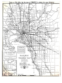
Map, Gawler and Drummond Architects, "Railway and Tramway Map of Melbourne and Suburbs", 1920's?
... "Railway and Tramway Map of Melbourne and Suburbs"...Map - photocopy - titled "Railway and Tramway Map... Tourism Map - photocopy - titled "Railway and Tramway Map ...Map - photocopy - titled "Railway and Tramway Map of Melbourne and Suburbs", c1920 showing railways, cable, electric tramways and authorised electric additions. Shows the South Melbourne St Kilda tram line and some lines in the Footscray area as dotted. Prepared by Gawler and Drummond Architects. Has an advertisement for "Rolfes" tea along the top edge and "See Victoria First" - Government Tourist Office, corner of Swanston and Collins St.trams, tramways, map, footscray, st kilda, new tramway, melbourne, tourism -
 Ballarat Tramway Museum
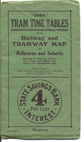
Ephemera - Timetable/s, Osboldstone & Co Pty Ltd and Printers and Publishers Melbourne, "OSBA Tram Time Tables with Railway and Tramway Map, of Melbourne and Suburbs", 1920's
... "OSBA Tram Time Tables with Railway and Tramway Map, of... with Railway and Tramway Map, of Melbourne and Suburbs". Published... Tram Time Tables with Railway and Tramway Map, of Melbourne ...Yields information about the tram timetables applicable to Melbourne's trams, including cable and electric and demonstrates the spread of Melbourne's public transport system in the early 1920's.Forty Eight page printed book contained with oversize green heavy paper covers centre stapled with a coloured map glued into the rear cover of the book titled "OSBA Tram Time Tables with Railway and Tramway Map, of Melbourne and Suburbs". Published c1920 - shows Footscray system, Victoria St Flemington link, does not show Puckle St. Timetables details Fares, first and last cars for cable and electric lines, sections and other details of the various lines. Note page 44 and 45 cannot be accessed, paper not cut correctly during the printing process - leave as is. Map prepared by Gawler and Drummond Architects, shows in colour the cable routes, electric tramways, authorised tramways and railway lines. Municipalities shown in different colours. Map folded into 12 sections. Published by Osboldstone & Co Pty Ltd, Printers and Publishers, Temple Court Place, Melbourne. Price 6d. Full scan of document added as a pdf file 5/6/2019. map, timetables, melbourne, cable trams -
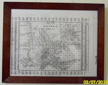 Sunshine and District Historical Society Incorporated
Map (1939), RAILWAYS OF VICTORIA, Including Passenger Mileage, 4 April 1939, 1939
... Railway map...Map showing the RAILWAY LINES of VICTORIA plus PASSENGER..., Hampshire Road, Sunshine 3020. melbourne Map (1939) RAILWAYS ...Historical record of the railway line system in the state of Victoria in 1939. Many of the railway lines no longer exist.Map showing the RAILWAY LINES of VICTORIA plus PASSENGER MILEAGES as of 4.4.1939. The white map with black printing is enclosed within a glass faced brown stained wooden frame.victoria, railway map, 1939, rail, passenger mileage -
 Dandenong/Cranbourne RSL Sub Branch
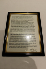
Document - Framed Information Sheet, About The Map, Circa 2000s
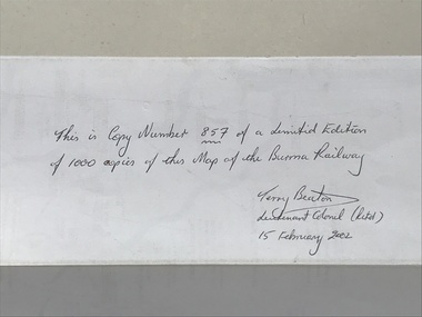
... The map was produced using a number of older railway maps... using a number of older railway maps, including the Escritt ...The information sheet belongs with a map showing the Burma Thailand Railway and it's route with the various camps and P.O.W centres. The map was produced over a period of 15 months and drawn in four stages. Shows Hellfire Pass formerly ( The Konyu Cutting). The 50 Kilo Camp in Burma. There were 56 stations and 87 camps on the route of the map. The map gives due credibility and was released as a limited edition of 1000 copies only. Copies of the map are displayed all over the world including Staffordshire in England, University of Houston, National Guard Museum of Texas and on display at the Australian and New Zealand Embassies in Bangkok.Framed information sheet of the map produced to show the various camps and sights along the Burma Thailand railway. The map was produced using a number of older railway maps, including the Escritt translated map and a local Thai road touring map. -
 Federation University Historical Collection
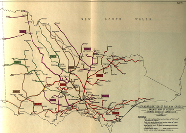
Book, Standardization of Australia's Railway Gauges, 1945
... are carried out * Map of Australian railways as of 30 June 1944 *Map... are carried out * Map of Australian railways as of 30 June 1944 *Map ...Sir Harold Winthrop Clapp KBE (7 May 1875 – 21 October 1952) was a transport administrator who over the course of thirty years had a profound effect on Australia's railway network. In two decades as its Chairman of Commissioners, he revolutionised Victorian Railways, with unprecedented attention to customer service and innovations such as more powerful locomotives, air-conditioned carriages, and faster services culminating in the introduction of the flagship Spirit of Progress express train. Seconded to the Federal Government in World War II, he played a pivotal role in the manufacture of fighter aircraft in the defence of Australia. As Director-General of Australia's Land Transport Board, he presented a report on railway gauge standardisation that ultimately led to the eventual linking of all Australian mainland capital cities by a uniform rail gauge. (http://en.wikipedia.org/wiki/Harold_Winthrop_Clapp, accessed 02/10/2013)Grey, soft covered, stapled report of 89 pages. "Standardization of Australia's Railway Gauges" by Harold Clapp is a report and recommendation regarding the standarization of Australia's railway gauges. The contents include: * Lines suggested for conversion or new lines to be constructed * scheme of conversion of tracks and structures * scheme of conversion of locomotives and rolling stock * Estimated costs * Associated works * Estimated manpower which the project will absorb in its various phases *Standardization of rolling stock * Other considerations associated with the project * Estimated time involved in the various phases of the work. The report includes 8 maps: * Map of Australia showing the various proposals referred to *Map of Australian railways showing extent of standard gauge if proposals are carried out * Map of Australian railways as of 30 June 1944 *Map of Australia showing principal mileages referred to in the report * Railway Map of Western Australia, 1945 * Railway Map of South Australia, 1945 * Railway Map of Victoria, 1945 * Railway Map of Melbourne Suburbs, 1945 railway, guage, standardization, standardisation, fremantle, perth, kalgoorlie, peterborough, silverton, tramway, tram, train, townsville, dajarra, bourke, cunnamulla, charleville, blackall, longreach, winton, hughenden, townsville, gajarra, birdum, darwin, narrow gauge -
Whitehorse Historical Society Inc.
Document, McGlone's Estate Mitcham, 1/04/1921 12:00:00 AM
... Street and Mitcham railway line and station. Original in Haughton ...Copy of pamphlet of McGlone's Estate, Mitcham auctioned April 1921.Copy of pamphlet of McGlone's Estate, Mitcham auctioned April 1921. 24 allotments. Bordered by Whitehorse Road, McGlone Street, Station Street and Mitcham railway line and station. Original in Haughton maps, LaTrobe Library.Copy of pamphlet of McGlone's Estate, Mitcham auctioned April 1921. land sales, auctions, mcglone, john, mcglone, elizabeth, whitehorse road, mitcham, mcglone street, mitcham, station street, mitcham, mitcham railway station, haughton map collection, state library of victoria. latrobe library -
Port Melbourne Historical & Preservation Society
Flyer, Victorian Railways, Sandridge Rail Trail, 2005
... in background. Fold out section has history of railway, map, walk... out section has history of railway, map, walk and ride ...Fold out flyer with black and white picture of train and three men on front cover. Back cover coloured image from Latrobe picture collection of park-like setting with steam train in background. Fold out section has history of railway, map, walk and ride descriptionstransport - railways, recreation, piers and wharves - station pier, piers and wharves - railway pier, hobson's bay railway company, melbourne and hobson's bay united railway company, montague street station, golden fleece hotel, st barnabas anglican church, north port station, lord raglan hotel -
 Ringwood and District Historical Society
Flyer, Land Sale Brochure, Heathmont Estate, Vic. - circa 1960
... Estate, opposite Heathmont Railway Station, with map and locality... of residential lots - Heathmont Estate, opposite Heathmont Railway ...Advertisement for sale of residential lots - Heathmont Estate, opposite Heathmont Railway Station, with map and locality plan.Subdivision includes Canterbury Road, Royal Avenue, Coleman Street, Stoda Street, Herman Street, and Campbell Street. Agent - A.W. Dickson, opposite Station, Ringwood. Phone WU6007. -
 Warrnambool and District Historical Society Inc.
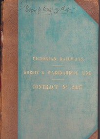
Document - Victorian Railways. Koroit & Warrnambool Line. Contract No. 2937, Circa 1888
... railway station. Early Victorian railway maps indicate... Little Collins Street, Melbourne. The Victorian Railways began ...The Victorian Railways began in 1854 and in the first 14 years up to 1868 had managed to complete about 250 miles of track. The next 60 years saw the system expand to nearly 3000 miles. By 1931 every town with a population over 500 had its own railway station. Early Victorian railway maps indicate that the extension from Colac to Warrnambool and then onwards to Koroit, occurred in the period of the 1880’s when the act known as the Octopus act saw a rapid expansion of lines. At the time there was much debate over where the expansion of the lines should take place, with one of the prime considerations for Warrnambool was the impact it would have on its port.The building of the railway to Warrnambool and onward to Koroit was a significant event for the town. Green cloth cover with tan suede corner points and spine. Title printed in gold on front cover. Title printed in gold on red on spine. 92 pages. The contract is printed and includes handwritten entries with specifications.Handwritten on front cover and inside front cover ” Copy for Engr in Chief” .On Page 2 transferred to Allan Reid * 24/1/88 Co Briscoe & Co Little Collins Street, Melbourne.warrnambool, railways, warrnambool to koroit railway, victorian railways contract no 2937 -
 Marysville & District Historical Society
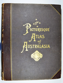
Book - Hardcover book, Picturesque Atlas Publishing Company Limited, The Picturesque Atlas of Australasia-Volume 2, 1886
... the head of a ram. Three fold-out maps are included; Railway Postal...; Railway Postal and Telegraph Map of South Australia, 1888; Railway ...The Picturesque Atlas of Australasia-Volume 2Hardcover. Cover is brown with the title in gold lettering. Underneath the title is a symbol of a solid wreath surrounding the head of a ram. Three fold-out maps are included; Railway Postal and Telegraph Map of South Australia, 1888; Railway Postal & Telegraph Map of Queensland, 1888; Railway, Postal, Telegraph and Rainfall Map of Tasmania 1889. non-fictionThe Picturesque Atlas of Australasia-Volume 2atlas, australasia, history -
 Melbourne Tram Museum
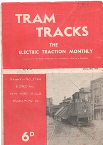
Magazine, Jack Richardson, "Tram Tracks - The Electric Traction Monthly", Jan. 1949
... Experience", Brisbane, Newcastle, Sydney, Monorails, railway map..., railway map of Australia track gauges, (centre page), Brisbane ...Vol. 4 No. 1, January 1949 of "Tram Tracks - The Electric Traction Monthly" of the Australian Electric Traction Association. Magazine consists of 20 printed pages, with a single staple on the saddle. Contains a photo of the construction of the Victoria Parade tram line, article "Trams and the Motorist", items on Melbourne (Bourke St, "Higher costs with Buses - Melbourne Experience", Brisbane, Newcastle, Sydney, Monorails, railway map of Australia track gauges, (centre page), Brisbane Tramways, Melbourne and Sydney electric trains, and letter to the Editor from John Buckland - not supportive of Bourke or Latrobe St tramways. Issue has advertisements for the Model Dockyard, ARLHS, The Hobby Shop, Barnes Tennis Centre, Fleet, Christie Model Railway Equipment of Sydney, Meadmore Model Engineering, Austral Bronze, Wattle Park, Traction Publications and Robilt "O" gauge locomotives, Parker & Gray, The Model Dockyard,Has initials "JBS" in top right hand corner in pencil.trams, tramways, electric traction, aeta, australian tramways, mmtb, pcc, sydney, newcastle, brisbane, bourke st -
 Dandenong/Cranbourne RSL Sub Branch
Map - Burma - Siam Railway
... Is of Historical significance. This map was put together... Dandenong melbourne Burma - Siam Railway. Map Framed picture map ...Is of Historical significance. This map was put together by T.R.Beaton on the 15th February 2002. He used old railway and road maps to show the route and it took him over 15 months to put together. T.R. Beaton was Manager/Curator of Australian Government Memorial Museum built above " Hellfire Pass " or Konyu Cutting.Framed picture map of the Burma _ Siam Railway. -
 Ballarat Tramway Museum
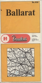
Map, Broadbent's, "Broadbent's Map 616 Ballarat", c1960
... and historical interest. also shows railways lines. Map used... and historical interest. also shows railways lines. Map used ...Yields information about the extent of Ballarat in the early to mid 1960's shows the tram lines and other rail lines in the district.Printed street map titled "Broadbent's Map 1616 Ballarat" printed in colour on one side only of a folded (10) sheet. Shows the suburbs of Ballarat, tram lines, has a scale in miles, Ballarat District map and an index to streets. Also points interest and historical interest. also shows railways lines. Map used as the base for the tram line map in the display area in the depot. Large Res scan made 28/1/2011."50c" in pencil on front cover.trams, tramways, map, ballarat, broadbent's, railways -
Glen Eira Historical Society
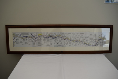
Map - Victorian Railways
... This file contains three items. 1. Original railways grid... VIC 3162 melbourne Victorian Railways Map This file contains ...This file contains three items. 1. Original railways grid map of Victoria with passenger mileages (in miles) which shows railway stations in Glen Eira as part of the rail network. 2. Original pamphlet titled ‘Pocket History Vicrail 1839 – 1981’, dated 1981. Chronological history of milestones and dates, ie. 1981 Caulfield loop opened 24/01/1981 as part of underground rail loop. Image on front cover shows 2 images (steam train and stainless steel train). 3. Original pamphlet by Ministry of Transport titled ‘Your neighbourhood Public Transport System’ outlining fare structure. Stylised map of Caulfield (Glen Eira) neighbourhood.carnegie, bentleigh, caulfield, elsternwick, glenhuntly, ormond, murrumbeena, railways, public transport, bus, train, tram, railway stations, ‘vicrail’, underground rail loop -
 Mont De Lancey
Book, A. H. Massina & Co, A.H. Massina and Co's Weather Almanac and General Guide and Handbook for Victoria for 1894, 1901
... of Railway Systems. It has advertisements, tables, calendars, maps... with Calendar and Map of Railway Systems. It has advertisements, tables ...A plain red hardcover book - Weather Almanac and General Guide and Handbook for Victoria 1894. A.H.M. & Co's Almanac 1894 - 01. There are maps, calendars, diagrams and general information throughout the book for the guidance of village settlers.A red hardcover Weather Almanac and general Guide and Handbook for Victoria for 1894 - 01 with Calendar and Map of Railway Systems. It has advertisements, tables, calendars, maps, memoranda tables, diagrams and other notes of general interest throughout. non-fictionA plain red hardcover book - Weather Almanac and General Guide and Handbook for Victoria 1894. A.H.M. & Co's Almanac 1894 - 01. There are maps, calendars, diagrams and general information throughout the book for the guidance of village settlers.almanacs, documents, calendars -
 Marysville & District Historical Society
Book - Hardcover book, Picturesque Atlas Publishing Company Limited, The Picturesque Atlas of Australasia-Volume 3, 1886
... the head of a ram. A fold-out map is included; Railway Postal... surrounding the head of a ram. A fold-out map is included; Railway ...The Picturesque Atlas of Australasia-Volume 3Hardcover. Cover is brown with the title in gold lettering. Underneath the title is a symbol of a solid wreath surrounding the head of a ram. A fold-out map is included; Railway Postal and Telegraph Map of the North Island of New Zealand, 1889. non-fictionThe Picturesque Atlas of Australasia-Volume 3atlas, australasia, history -
 Melbourne Tram Museum
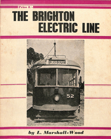
Book, Leon Marshall-Wood, "The Brighton Electric Line", 1956
... by the Victorian Railways. Includes maps, rolling stock and an Epilogue... tramway operated by the Victorian Railways. Includes maps, rolling ...Book - 20 pages - the history of the Brighton Electric Line by Leon Marshall-Wood, published 1956, 1st edition. Gives a brief history of the electric tramway operated by the Victorian Railways. Includes maps, rolling stock and an Epilogue. Published by Traction Publications. Has details of the AETA on the back cover and listing of some publications. See Reg Item 1351 for the 3rd edition. Items 2062, 614 and 2063 within box 72.3 in a brown folder marked "Brighton Electric Street Railway" in ink on the front cover. See 3400 for the 2nd edition.trams, tramways, vr, melbourne, brighton, st kilda -
 Melbourne Tram Museum
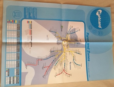
Poster, Metcard, "Metcard Fares and Zones", 2000
... showing Melbourne's Train or suburban railway station system (same... Trams tramways Metcard Fares Connex M>Train Map Tickets Railway ...Poster - A1 size, printed on heavy paper, full colour showing Melbourne's Train or suburban railway station system (same map as Reg Item 2510), titled "Metcard Fares and Zones". Shows the relevant Metcard fares, dated 1/1/2001. Has the areas that M>Train and Connex were responsible for.trams, tramways, metcard, fares, connex, m>train, map, tickets, railway station -
 Eltham District Historical Society Inc
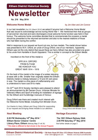
Newsletter, No. 216 May 2014
... • Next Meeting • Heritage Excursion – The 1901 Eltham Railway... – The 1901 Eltham Railway Walk • May Meeting – Maps, Manuscripts ...Contents: • Welcome Home Medal by Jim Allen and Jim Connor • Next Meeting • Heritage Excursion – The 1901 Eltham Railway Walk • May Meeting – Maps, Manuscripts and Menus; telling stories via heritage collections (Liz Pidgeon) • May Excursion – The 1901 Eltham Railway Walk • Subscriptions • Vera Addison • Vale John Cohen OAM 19/9/1919-18/3/2014 • Mayoral Chain of Office • Eltham Library – 20th Anniversary • St Margaret’s Church Eltham • Office Bearers 2014-2015 • And Also • Contacts for the Eltham District Historical Society The Shire of Eltham Historical Society was formed in October 1967. The first newsletter of the Society was issued May 1978 and has been published continuously ever since on a bi-monthly basis. With the cessation of the Shire of Eltham in late 1994, the Society's name was revised to Eltham District Historical Society and this name first appeared with issue No. 103, July 1995. The collection of the Society's newsletters provides a valuable resource on the history of the Society's activities, office bearers and committee members, guest speakers and subjects of historical interest pertinent to the former Shire of Eltham and the Eltham District.A4 photocopied newsletter distributed to membersnewsletter, eltham district historical society, shire of eltham historical society -
Glen Eira Historical Society
Letter - Rosstown Railway
... of the a partial map of the Rosstown Railway and surrounding area, undated... Railway and surrounding area, undated. The map includes the names ...This file contains four items: 1/A black and white photocopy of a letter dated either 07/08/1889 or 09/08/1889, from Robert Lundon to an unidentified recipient discussing an agreement reached between the author – on behalf of the recipient – and Soon Hang Hi in regard, in regards to the allotment known as Webber’s. The agreement is outlined in the letter in what appears to be Chinese characters, and includes the marks of Robert Lundon and Soon Hang Hi. File note from Joy Wu states that the calligraphy is not Mandarin or traditional Chinese. 2/Three sheets of hand-written working notes with information taken from the Victorian Government Gazette on THE ROSSTOWN AND MURRUMBEENA LAND COMPANY LIMITED, THE ROSSTOWN JUNCTION RAILWAY AND PROSPERITY COMPANY LIOMITED, and THE ROSSTOWN JUNCTION, ELSTERNWICK, AND OAKLEIGH RAILWAY COMPANY LIMITED, covering dates between 1887 and 1894. The notes concern meetings and creditors claims relevant to the companies, with reference numbers for the information source. Date and author of the notes are not recorded. 3/A black and white photocopy of the a partial map of the Rosstown Railway and surrounding area, undated. The map includes the names of landholders in the areas of Brighton, Garden Vale and Elsternwick, as well as other railway lines present in the region. 4/A fold-out map and guide of the Rosstown Rail Trail, including a brief general history of Caulfield as well as a more extensive biography of William Murray Ross and the Rosstown Railway. The map marks and describes significant sites along the trail, including photographs of some of these sites, provided by DF Jowett.documents, correspondence, webber’s, lundon robert, chinese characters, ethnic communities, signatures, text, settlements, taxes, fraser john grieves, lovell r.h., price davies, meetings, communication activities, soon hang hi, commercial events and activities, the rosstown and murrumbeena land company limited, victorian government gazette, bulmer richard, parry john, osment henry, shareholders, creditors claims, the rosstown junction railway and property company limited, finch and best, lawyers, the rosstown junction elsternwick and oakleigh railway company limited, cameron w.c., phillips p.d., garden vale, elsternwick, elsternwick railway station, rosstown, rosstown railway, thomas street, bay street, kooyong road, melbourne and brighton railway, hawthorn road, bambra road, caulfield and frankston railway, booran road, grange road, koornang road, murrumbeena road, north road, north road railway station, east brighton railway station, south road, railway routes, railway lines, railways, land transport, murphy j., caulfield, hamilton t.f., dane p., holloway, webb, ailee john, payne t.b., brodie chas, dane john, o’neil h., mccombie john, mcmillane a., smyth c.d., cooper, ebden, landholders, jeffrey j.d., gill j., balcombe a.e., cooper h., mcnab j., white j., sutherland j., greeves a.f.a., newton m.c., chamley f.b., fowler j., inglis p., grant t., stooke j., swanson g., cochrane c., adams e.b., mccombie thas, keyes robert, brighton cemetery, burials grounds and graveyards, war-ein road, were j.b., holland j., mcmahon c., winter t.l.m., dendy henry, mitchell w., jackson s., were j.e., wickham francis dawe, bryant jane, east brighton railway station, railway stations, maps, allotments, land titles, roads and streets, rosstown rail trail, city of glen eira, tourism, trains, tourism information bureaus, tours, pamphlets, elsternwick railway park, oakleigh junction, princes park, ee gunn reserve, packer park, sites, jowett d.f., weickhardt i.g., return to rosstown: railways land sales and sugar beet ventures in caulfield, land sales, walking trails, ross william murray, transport objects, locomotion, walking, cycling, driving, sports, country mansions, people, caulfield john, builders, construction and demolition workers, occupations, careers, professionals, topography, geology, landforms, horticulture, market gardens, primary industry workers, city of caulfield, mood kee, pennington harold, annual general meetings, caulfield town hall, glen eira city council, carnegie, carnegie station, rosstown station, people by circumstance, migrants, sugar beet, sugar beet mill, sugar beet industry, mills, factories, sea beach lines, bent thomas, parliamentary representatives, neville street, miller street, lemann’s swamp reserve, koornang park, cane sugar industry, breweries, rabbit processing plants, health establishments, hospitals, food production establishments, abattoirs, thieves, social problems, vagrants, theft, squatting, financial economics, debt, finance industry, insurance companies, company managers, bentleigh, ross leila, the grange, leila road, wild cherry road, financial trouble, mortgages, gisborne street, archibald street, riddell parade, victoria railways, glen huntly road, clarence street, college street, gladstone parade, parrell street, aileen avenue, seaview street, drion estate, land subdivisions, dover street, sussex street, landfill, marara road, booran road, woodville avenue, dorothy avenue, ormond park, royal avenue, ormond railway station, oakleigh road, melten avenue, miller street, munro avenue, lord reserve, neerim road, toolambool road, the rosstown hotel, rosanna street, murrumbeena crescent, commercial establishments, the national bank, rosstown road, kangaroo road, poath road, freda street, hughesdale kindergarten, oakleigh council, hughesdale community centre, civic establishments, galbally reserve, plaques, warrigal road, out and about brochures